Sunday, October 29, 2006

Scattered Thundershowers


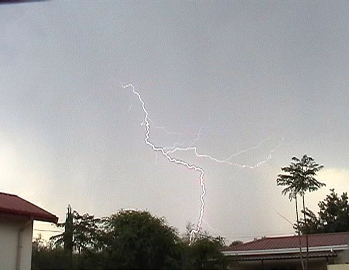
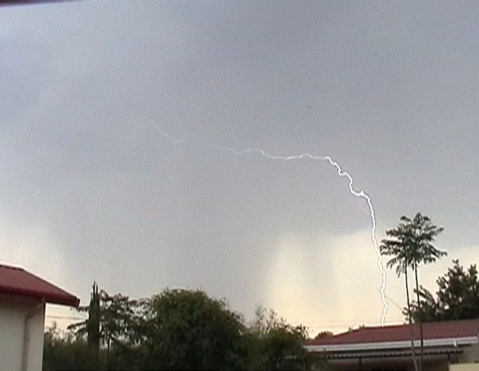
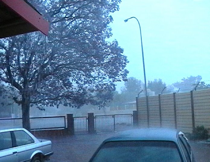
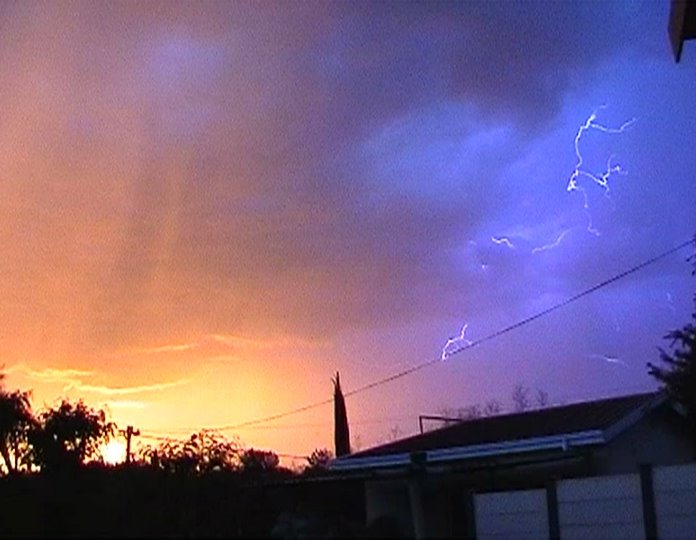
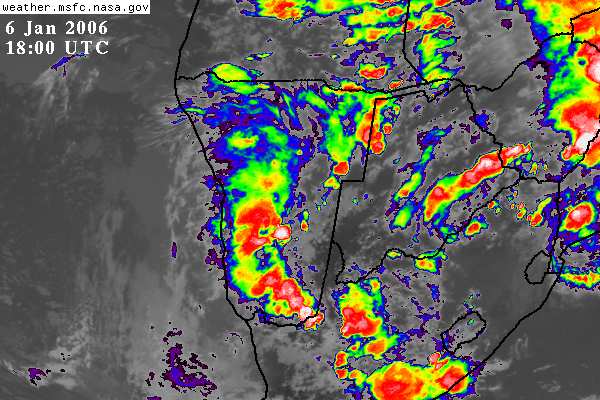
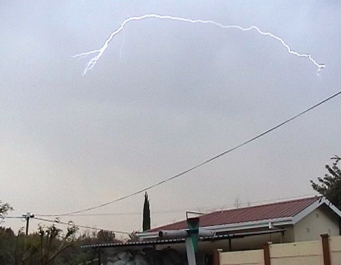
A really good build up looked very promising for a good thunderstorm this afternoon. When the lightning action began however, there was mostly could to cloud lightning above us which was not visible above the cloud cover. You could hear the crackling and rumbling right overhead, which was a bit concerning at one stage. You never know when you’re going to have a ground strike from above you in conditions like that it could be any moment. This thunderstorm was a bit frustrating, as we did not get much rain out of it. The storm moved in from the north and then quickly moved east of Windhoek, towards the International Airport and headed out towards the small town of Gobabis.
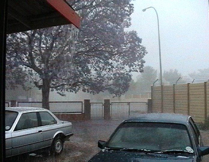
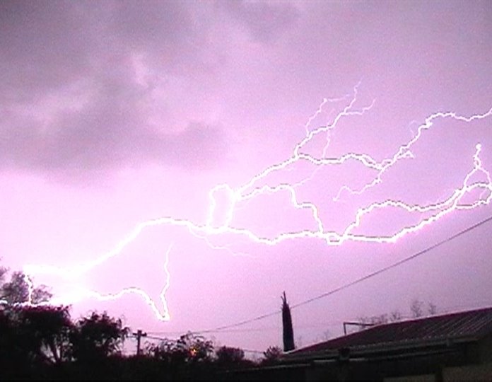
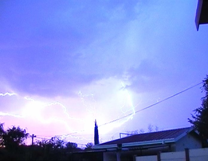
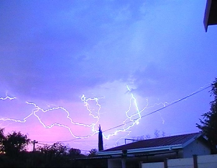
So unfortunately we did not get a spectacular thunderstorm as expected. Well I suppose a bit of rain is better than no rain at all… even if it’s only 2 mm! These were the only lightning pictures I managed to get for the day. Better than nothing!

Wednesday, October 25, 2006

Hot Conditions


Conditions in Windhoek have been very hot since Sunday 15 October 2006 thunderstorm which brought over 50 mm in a very short period of time. Temperatures are reaching the mid to high 30 degrees Celsius. There have been rumors that some areas will still reach up to 40 degrees Celsius! It seems the whole of Southern Africa is experiencing very hot conditions with little or no rain activity. Temperatures at 08H00 have been up to 23 degrees Celsius in the mornings. The temperatures on the map are in Fahrenheit. Consumption of large amounts of beer is a must for survival. In general the amount of beer consumed in Namibia is directly proportional to the increase in temperature. So the higher the temperatures the more beer one needs to drink.

Friday, October 20, 2006

Harnessing Lightning for Electricity

Harnessing Lightning? Personally I am sceptical about the whole thing.
There was a story about an attempt to harness a lightning bolt some
years back with a massive capacitor - the whole lot blew up, which is no
surprise at all. That was then, but now Alternative Energy Holdings
(AEHI), want to be the first to harness lightning and eventually sell of
the electricity for cheap. Now I have done a little thinking on the
subject and have been wondering just how they intend to pull this off.
Obviously their technology and methods will be closely guarded. However
there is mention of "collecting power from the area surrounding the
lightning strike" which gets me thinking that maybe they will not be
using some 'lightning hits the pole and then into the lightning holding
chamber sort of thing'. Those ideas tend to blow up in ones face, like
the capacitor story. Power from surrounding ground brings on a totally
different approach, which means they could be using the ground as a sort
of shock absorber so you don't get the brunt of a strike which fries
everything. When lightning hits the ground some of the energy also moves
outwards in a circle and dissipates, much like throwing a stone in a
pond. So if the outer energy is a bit less potent, it could be a bit
more manageable for whatever device to store some of the energy, and not
blow up. The next clue is that there is mention that the supply of
electricity to the public will only be after 4 - 7 years after
successfully tapping lightning. What? Why so long? I think the answer
there could be because they will not be capturing the full force and
power of the lightning strike, but rather smaller doses. So, maybe when
it comes to harnessing lightning, one needs to think small to think big.

Monday, October 16, 2006

Wernhil flooded...

Yesterday's heavy rains in Windhoek caused major damage to several shops in the Wernhil shopping centre. Late yesterday blockages caused by building materials in a stormwater drain which runs past Wernhil were being blamed for the shopping centre being flooded - the water rushed in from the parking bay side. At around 18h10, the water in shops was ankle-deep.

Sunday, October 15, 2006

Unexpected thunderstorm!

Just before this thunderstorm, most of the lightning was not really visible because it was cloud to cloud lightning above the cloud base. This makes it a bit unsettling especially when you can hear it rumbling directly over head. There could be a close ground strike at any second! In the picture below is a bit of a bit of cloud to cloud lightning. Unfortunately when the rain really came down, it cam down in buckets! It was raining so hard it was impossible to film any more lightning. You could not even open a window to peek through without getting the camcorder wet from the rain.The picture below shows a bit of hail coming down. Luckily it was small hale stones because the cars were outside. There were later reports that some had 30 centimeters of hail. Of course this can cause damage to flat roof houses because of the weight!


This is when it was really coming down, we had 52.5 mm in about 40 minutes. There was plenty of lightning activity during this time, but there was just no way to film any of it without getting soaked or possibly struck. The visibility was pretty low as seen in the picture above.

52.5 mm in approx 40 minutes! Bring it on!

Friday, October 13, 2006

Friday 13

Talk about tempting Friday the 13th! WOOOHA! Belows picture is just a fraction later than the picture above. These kind of lightning pictures get you thinking about what if? Being where this picture was taken from will get your heart racing a bit!


Belows picture is also a fraction later than the picture above. This was a bit earlier in the evening when things were still hotting up to a great lightning show.
Lightning warm ups. Now these two pictures are really fascinating! It's like looking at good and evil at the same time. Sunset on the left and brewing trouble on the right! May the force be with you...

Farmer Struck by Lightning!


In the a local news paper yesterday, it was reported that a 37 year old
farmer Mr. Jassie Brand was struck by lightning 2 weeks ago, in the
Outjo area on his farm Aimeb-Oos. According to the report, before going
to sleep that night, he was busy installing a new Marnet Radio system.
He was sitting on a wooden chair in front of his computer opening up the
cardboard box in which the new radio was, when the lightning struck him.
His finger and thumb were burnt off in the cardboard box. The pictures
in the report show the wooden chair with a burn imprint of his buttocks
on it. The second picture shows the desk where the computer was, the
keyboard is split in two and all the keys blew off with such force they
left imprints on the ceiling! A third picture shows the charred
cardboard box which he was handling at the time. He was unconscious and
found by the farm workers the next morning and rushed to hospital. No
one at the time was sure what had happened until the doctors examined
him and realised he had been struck by lightning. His back and buttocks
were burned and the socks in his shoes had melted to his feet. His hair
was singed and busy falling out. He has survived the whole ordeal and is
having problems focusing his eyes. Doctors believe that if he was not
wearing the rubber soled shoes, he would probably been killed!

Thursday, October 12, 2006

Fortune

Unfortunately for us, but fortunate to others, that lovely growing thunderstorm wandered around here for a while building and building. Moving from the south to the east, and then well, moved so far north we could only see the flashes of lightning in the distance. It was so far away we could not even hear the thunder anymore. Bit of a let down really, with only 2 mm of rain. We almost drowned!

Wednesday, October 11, 2006

Thunderstorm in the making!

Today the clouds have built up quite well! There have been spits of big rain drops this afternoon, and there has been some rumbling to the south, where there is a nice developing cell. Thunderstorms have been predicted for today which will probably occur this evening. The winds are becoming erratic which is a good sign for possible lightning activity. Some cells are also beginning to join up with other cells. Temperature this morning at 08H00 was 20 degrees celcius. I hope this is going to be a real cracker!

Tuesday, October 10, 2006

Thunderstorm Frustration

Since the last post, the weather has been no more than just pain frustrating! The clouds keep building up only to disappear again in the late evening without doing much at all. One good sign though is that the upper air movement is mostly from North North West to North North East. This is good because it brings moisture into Namibia from Angola. I suppose it is still a bit early in the season, and I am being a bit impatient. The temperatures are not quite where they aught to be for some real good thunderstorms yet, so we will have to wait a bit longer for the major action to get underway. There was a bit of lightning activity to the east and south on Saturday, but nothing that spectacular. The camcorder was out just in case and all what happened was a couple of bangs to the east, which I missed because I was setup for possible activity to the south.
The two or three strikes to the east must have been pretty good, because the reflection on the clouds to the south from those strikes was almost blinding!

Friday, October 06, 2006

Temperature Increases

Finally Friday and the temperature is getting back up again after a cold
spell from Monday to Wednesday. Today however we have gone from the cold
blue skies, to a nice over cast day with a hint of possible
thundershowers late this afternoon. There is plenty of moisture in the
air so it should get more humid as the day wares on. Hold thumbs for
some rain!

Thursday, October 05, 2006

Namibia Satellite Image


Thought I would post this Satellite image to give you an idea of the thunderstorms we can get here. This image is from the last storm season which brought heavy rain throughout the hole country and caused flooding in many places. Flooding occured in parts of Windhoek. Flooding also accured in Swakopmund, Walvis Bay and Luderitz! Thunderstorms are not common for coastal towns. Mariental in the south of the country was submurged under water as they had to open the Hardap Dam sluice gates to release water just north west of the small town.

Tuesday, October 03, 2006

Cold Spell Kills Thunderstorms.

Weather suddenly took a dramatic turn early Monday with chilly weather.
Today was even colder with the temperature a 0 degrees Celsius this
morning! These are those last die hard winter days, which still try and
sneak back on you before summer is back in full swing. There is no chance
of any thunderstorm activity in these sort of conditions. Fortunately this
sort of thing only lasts about 3 days or so, and then we should be getting
back to the normal temperatures again. Good temperatues for thunderstorms
are usually around 30 and above.

Sunday, October 01, 2006

Finally the first lightning Picture!


Ok, here are a couple of the first lightning pictures taken yesterday. These are the first of the season. All the lightning was mostly cloud-to-cloud lightning and as I mentioned on average about 10 seconds away. Today there are some clouds around, but don’t look like they will bring any thunderstorms. So on this Sunday we decided to have a nice braai / barbeque, and chill out with some beers instead. The nice sunset was taken just after the afternoons lightning action! What a great start to the thunderstorm season. The thunderstorms at this time of the year are still small and by no means extreme yet, but they will intensify, as the season gets under way!

Arc lightning cloud to cloud

Cloud to cloud lightning

Sunset after the Action


Sunset after the afternoons lightning.